Major winter storm continues impacting the state. Heavy snow occurring in Southern Connecticut is expected to move farther inland during the day. Up to 24 inches of snow is expected. Southbury Town Hall and Public Library are closed. We encourage all residents to stay home and stay safe so our Public Works crews can clear the roads.
Please see below for detailed snow information from the State Emergency Operations Center. The Southbury Emergency Management Team will continue monitor weather conditions and provide updates as they are available.
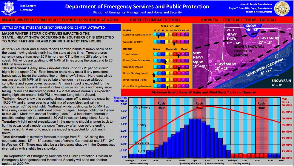
At 11:45 AM radar and surface reports showed bands of heavy snow near the coast moving slowly north into the state at this time. Temperatures currently range from near 20 F in northern CT to the mid 20’s along the coast. NE winds are gusting to 40 MPH at times along the coast and to 25 MPH at times inland.
This Afternoon: Heavy snow (snowfall rates up to 1” - 2” per hour) with highs in the upper 20’s. Even heavier snow may occur if any persistent bands set up inside the dashed line on the snowfall map. Northeast winds gusting up to 50 MPH at times by late afternoon may cause whiteout conditions and some power outages. A major impact is expected for the afternoon rush hour with several inches of snow on roads and heavy snow falling. Minor coastal flooding (tides 1 – 2 feet above normal) is expected during high tide around 1:00 PM in western Long Island Sound.
Tonight: Heavy snow this evening should taper off to moderate snow by 10:00 PM and change over to a light mix of snow/sleet and rain in southeastern CT by midnight. Northeast winds gusting up to 50 MPH at times may cause some additional power outages. Temps holding in the low to mid 30’s. Moderate coastal flooding (tides 2 – 3 feet above normal) is possible during high tide around 1:30 AM in western Long Island Sound.
Tuesday: A light mix of precipitation in the morning should change back to light to occasionally moderate snow Tuesday afternoon before ending Tuesday night. A minor to moderate impact is expected for both rush hours.
Total Snowfall: Is currently forecast to range from 8” – 12” along the southeast coast, 12” – 18” across most of central Connecticut and 18” – 24” in Western CT. There may also be a slight snow shadow in the Connecticut river valley with slightly less snowfall.